MissLou Drone Services FAQ
Interview with a certified drone pilot
Introduction and Background
Can you tell us a bit about your background and experience with drones? How did you get started?
I began flying & building Remote Control vehicles 25 years ago and have over 250 hours flying actual aircraft.
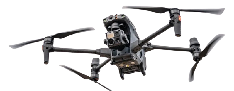
What kind of drones do you typically fly, and what are their capabilities?
I prefer DJI brand drones, not due to brand loyalty but simply they have most advanced equipment and their customer support is excellent.
What are some of the most common uses for drones in your line of work (e.g. aerial photography, surveying, inspection)?
Aerial Photography and Videography: Drones are widely used in the film and media industry to capture stunning aerial footage and photos. They’re also used in real estate, tourism, and marketing to showcase properties, destinations, and products.
Surveying and Mapping: Drones equipped with GPS and sensors can create highly accurate 3D models of landscapes, buildings, and infrastructure. This is useful in construction, urban planning, and environmental monitoring.
Inspection and Monitoring: Drones are used to inspect critical infrastructure like bridges, power lines, and pipelines. They’re also used to monitor crops, detect issues in industrial facilities, and track wildlife populations.
Construction and Site Monitoring: Drones help construction teams monitor site progress, track changes, and identify potential issues. They’re also used to create detailed site plans and monitor equipment and material deliveries.
Environmental Monitoring: Drones are used to track environmental changes, such as monitoring water quality, detecting oil spills, and observing wildlife habitats.
Disaster Response and Recovery: Drones are used to assess damage after natural disasters, such as hurricanes, earthquakes, or floods. They help emergency responders identify areas of need and prioritize relief efforts.
Agricultural Monitoring: Drones are used in precision agriculture to monitor crop health, detect issues, and optimize irrigation and fertilizer application.
Infrastructure Inspection: Drones inspect hard-to-reach infrastructure, such as bridges, dams, and wind turbines, to identify potential issues and reduce maintenance costs.
Archaeological and Cultural Heritage: Drones are used to document and preserve cultural heritage sites, such as ancient ruins, monuments, and historical buildings.
Research and Development: Drones are used in various research applications, such as studying weather patterns, monitoring climate change, and testing new technologies.
These are just a few examples of the many uses for drones in my line of work. The versatility and flexibility of drones make them an invaluable tool in a wide range of industries and applications.
How do you ensure safe drone operations, particularly in populated areas or near other aircraft?
Pre-Flight Planning: Before flying, I thoroughly plan the flight, taking into account factors like weather, air traffic, and obstacles. I use tools like weather forecasts, NOTAMs (Notices to Airmen), and aeronautical charts to plan the flight.
Drone Maintenance and Inspection: I regularly inspect and maintain my drone to ensure it’s in good working condition. This includes checking the propellers, motors, batteries, and sensors.
Pilot Training and Certification: I’m a certified drone pilot, having completed training programs that covers safe drone operations, regulations, and best practices.
Visual Line of Sight (VLOS): I always maintain a visual line of sight with my drone, ensuring I can see it and any potential obstacles or other aircraft. The FAA is working on modifications to this regulation at present to allow for mapping, surveying, agricultural and other uses.
Airspace Awareness: I’m aware of the airspace I’m flying in, including any restricted areas, such as airports, military bases, or national parks.
Drone Tracking and Monitoring: The DJI Matrice drone, I primarily fly, has ADS-B (Automatic Dependent Surveillance-Broadcast) to monitor other aircraft and the interface is highly advanced allowing for precision monitoring of position and altitude..
Communication with Air Traffic Control: When flying near airports or in controlled airspace, I communicate with air traffic control to obtain permission and coordinate with other air traffic.
Avoiding Obstacles: I’m constantly aware of potential obstacles, such as trees, buildings, power lines, or other aircraft, and take steps to avoid them.
Weather Monitoring: I closely monitor the weather, avoiding flying in conditions that could be hazardous, such as strong winds, heavy rain, or low visibility.
Emergency Procedures: I have emergency procedures in place, such as a “return to home” function, in case of unexpected events like a lost signal or system failure.
Drone Geofencing: Some drones have geofencing capabilities, which prevent them from flying into restricted areas. I use these features to add an extra layer of safety.
Regulatory Compliance: I’m familiar with and comply with relevant regulations, such as Part 107 in the US, which governs commercial drone operations. Any commercial, i.e., drone operation for monetary compensation requires Part 107 certification, no exceptions.
For recreational pilots, In the United States, recreational drone pilots must follow specific regulations. These include:
Taking The Recreational UAS Safety Test (TRUST). It is a free aeronautical knowledge and safety test developed by the FAA.
Registering drones that weigh more than 0.55 pounds (250 grams).
Flying for hobby or recreation only; no commercial or in-kind work is allowed.
Flying below 400 feet.
Additionally, recreational drone pilots are advised to undergo a free safety training before flying a drone for the first time.
These regulations are part of the rules governing the use of Unmanned Aircraft Systems (UAS) or drones in the US, with the FAA being the primary regulatory body.
Future of Drones and the Industry
Where do you see the drone industry heading in the next 5-10 years?
Insurance will be heavily involved in drone usage for pre and post purchase commercial and residential inspection to establish condition prior to insuring. The drone industry is expected to experience significant growth in the near future. The global drone market is forecast to reach $58 billion by 2030, with some estimates as high as $77 billion. Further, Advancements in AI capabilities are expected to enable drones to make real-time decisions, recognize objects, and predict environmental changes by 2025. Overall, the drone industry is poised for rapid growth and transformation.
What role do you think drones will play in shaping our daily lives or transforming industries?
Revolutionizing industries such as defense, logistics, agriculture, entertainment, and construction through their versatility and capabilities.
Enabling applications like aerial photography, area coverage, precision agriculture, and environmental monitoring
Improving industrial inspections, search-and-rescue operations, and infrastructure maintenance through high-resolution cameras, thermal imaging, and sensors
Enhancing agricultural practices by mapping fields, applying fertilizers or pesticides, and monitoring crop health
Transforming the construction industry by monitoring progress, inspecting sites, and managing resources
Creating new job opportunities in manufacturing, software development, data analysis, and pilot training
Making jobs easier, safer, and more cost-effective across various sectors